The Great Rann of Kutch, is a seasonal salt marsh located in the Thar Desert in the Kutch District of Gujarat, India and the Sindh province of Pakistan. It is about 7,505.22 square kilometres (2,897.78 sq mi) in size and is reputed to be the largest salt desert in the world.
The Rann of Kutch is a geographically unique landscape that was once an arm of the Arabian Sea. As the land separated from the sea by geological forces, it became a vast, featureless plain encrusted with salt that is inundated with water during the rains. The Rann of Kutch is a unique and largest seasonal wetland of its type in India without any counterparts elsewhere in the world.
The Rann of Kutch is divided into the Greater Rann of Kutch and the Little Rann of Kutch. The Greater Rann of Kutch spans an area of 7505.22 Sq. km and is comparatively larger than the Little Rann of Kutch. The greater Rann Of Kutch is home to a wide array of flora and fauna. The Little Rann Of Kutch occupies 4,953 sq. km and is spread out in the districts of Surendranagar, Banasakantha, Patan, Kutch and Rajkot in Gujarat.
This is one of the hottest areas of India – with summer temperatures averaging 44 °C (111 °F) and peaking at 50 °C (122 °F). Winter temperatures reduce dramatically and can go below 0 °C (32 °F). Winter temperatures reduce dramatically and can go below 0 °C (32 °F).
It’s best to head out into the Rann of Kutch only in the early morning or evening, otherwise, the salt can be blinding. The full moon is the best time of the month to see it. A moon light Rann camel safari is magical. The Government of Gujarat hosts an annual 3-day festival called the Rann Utsav (festival of the Rann).
The Great Rann of Kutch, along with the Little Rann of Kutch and the Banni grasslands on its southern edge, is situated in the district of Kutch and comprises some 30,000 square kilometres (10,000 sq mi) between the Gulf of Kutch and the mouth of the Indus River in southern Pakistan. The marsh can be accessed from the village of Kharaghoda in Surendranagar District.
There are several wildlife sanctuaries and protected reserves on the Indian side in the Rann of Kutch region. From the city of Bhuj, various ecologically rich and wildlife conservation areas of the Kutch/Kachchh district can be visited such as Indian Wild Ass Sanctuary, Kutch Desert Wildlife Sanctuary, Narayan Sarovar Sanctuary, Kutch Bustard Sanctuary, Banni Grasslands Reserve and Chari-Dhand Wetland Conservation Reserve.
When winter settles in the water bodies of Great Rann of Kutch turns pink with the reflection of the drifting Flamingos. It is the only place in India where these feathered beauties lay eggs and bring up their chicks. About 13 species of larks have been reported from Great Rann of Kutch.
Kutch is also known for its intricate and appealing handicrafts. Rann Utsav is the ideal time to purchase the handicrafts since artisans from many parts of Kutch will flock the region with their best piece of work. Each of these brilliant crafts stands testimony to the creative ingenuity of the artisans of Kutch. The region has a great history of foreign trade in handicrafts with various countries. Even today the artifacts of Kutch have great demand in the national and international markets. Ethnic style embroidery, hand block painting, wood carving, silver work, pen-knives and nut crackers and sea shell toys and it goes on.
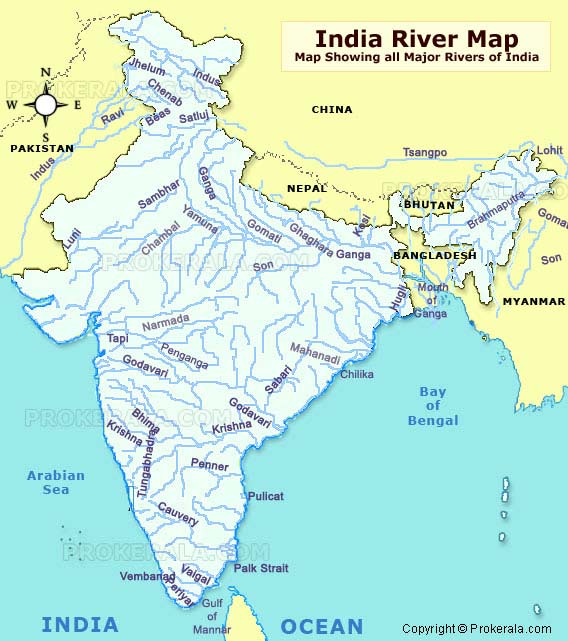
India is one of the top five countries in the world with favourable water resources (others are Canada, Brazil, Russia and Congo). Among the total water resources of the country, Indian rivers constitute the major share.The water in these rivers is used for various purposes including agriculture, production of electricity, storing water in dams and so on. Indian rivers are mainly divided into two types:
HIMALAYAN RIVERS
PENINSULAR RIVERS
HIMALAYAN RIVERS:
As the name suggests, these rivers originate from Himalayan Mountains. The sources of water are rainfall and melted snow. As they come from high altitudes they flow with high speed and have larger and deep courses. INDUS, GANGES, and BRAHMAPUTRA along with their respective tributaries are the main Himalayan Rivers.
SOURCE: The Indus River rises in Tibet near Manas Sarovar Lake. Flowing westwards, it enters India in Ladakh district of Jammu and Kashmir.
COURSE: It flows through the states of Jammu and Kashmir, Himachal Pradesh andPunjab in India then enters Pakistan and flowing further south reaches the Arabian Sea, east of Karachi.
TRIBUTARIES: Zaskar, Nubra, Shyok, and Hunza are the tributaries in India. Ravi, Chenab, Sutlej, Jhelum, and Beas are the tributaries in Pakistan.
CHARACTERISTICS: The slope is very gentle and with 2900 km length, Indus River is one of the longest rivers in the world.
THE GANGES RIVER SYSTEM:
SOURCE:The Ganges River originates in Gangotri glacier as Bhagirathi and joined by Alaknanda at Devprayag, It turns into Ganga.
COURSE: The Ganga River enters plains in Haridwar and from there it flows eastwards enlarged by the tributaries joining from left and right. The river divides in West Bengal and the distributary Hooghly flows southward to reach the Bay of Bengal. The main river enters into Bangladesh and joins with Brahmaputra river.It covers the states of Uttarakhand, Uttar Pradesh, Bihar and West Bengal.
TRIBUTARIES: Yamuna River joins Ganga at Allahabad as a right bank tributary. Ghagra, Gandak and Kosi Rivers arising from Nepal Himalayas join as left bank tributaries. Chambal, Betwa and Son rivers from central Highlands join as right bank tributaries. It covers the states of Uttarakhand, Uttar Pradesh, Bihar
CHARACTERISTICS: The length is 2500 km and the slope is almost steep in the Himalayas and gentle in the plains. With more number of tributaries, the basin of the river is very huge.
SOURCE: The Brahmaputra River originates in Tibet to the east of Manas Sarovar Lake.
COURSE: The Brahmaputra River mostly flow outside India from the point of its origin and in the middle course, enters Arunachal Pradesh and later into Assam. Then, it flows eastwards into Bangladesh. In Bangladesh, Brahmaputra River is called as River Padma.
TRIBUTARIES: In Arunachal Pradesh Dibang, Lohit and Kenula Rivers are its tributaries.
CHARACTERISTICS:The length of the river is 2900 km and is one of the longest rivers of the world.
PENINSULAR RIVERS:
These rivers are confined to the peninsular region and are dependent on rainfall for water. Unlike Himalayan Rivers, these rivers are shorter with small basins. NARMADA, TAPI, GODAVARI, KRISHNA, CAUVERY and MAHANADI are the main rivers.
NARMADA BASIN:
It originates in Amarkantak hills in Madhya Pradesh and flows towards the west to join the Arabian Sea. It covers the states of Madhya Pradesh and Gujarat.
TAPI BASIN:
It rises in Madhya Pradesh and covering the states of Madhya Pradesh, Gujarat and Maharashtra join the Arabian Sea.
It is known as DAKSHIN GANGA due to its area covered (over 1500 km). The Godavari River originates in Nasik in Maharashtra and covers the states of Madhya Pradesh, Orissa, and Andhra Pradesh. Flowing eastwards, it joins in the Bay of Bengal.
KRISHNA BASIN:
It rises near MAHABALESHWAR in Maharashtra and covering an area of 1300 km, it flows through Maharashtra, Karnataka, and Andhra Pradesh and reaches the Bay of Bengal.
CAUVERY BASIN:
Cauvery River originates in the Western Ghats and covering an area of 760 km, it reaches the Bay of Bengal in Tamil Nadu. The states covered are Karnataka, Kerala and Tamil Nadu.
Besides the above other rivers include Mahi, Sabarmati, Subarna Rekha and so on.
CONCLUSION:
All the rivers in India, despite their location, are considered holy by the people. There is a proposal of interlinking all the Indian rivers in order to utilise the waste flowing water in drought areas.
Generally, while travelling we observe that the Indian soils colour, texture changes from one region to the other. We cannot grow all type of crops in any soil. Different crops require different soil conditions. Especially, in the agricultural country like India with various crops, nature of the Indian soils play a very important role in planning the types of crops to be grown.
Soils have organic components like humus (formed from buried living organisms) and inorganic components like sand, silt, and clay. When the organic and inorganic components are in equal proportions, then the soil is said to be fertile. For agricultural purposes, we need fertile soils. Where the soils lack fertility, fertilizers are used.
The different types of soils found all over India are:
ALLUVIAL SOILS
BLACK COTTON SOILS
RED AND YELLOW SOILS
LATERITE SOILS
ARID SOILS
FOREST AND MOUNTAIN SOILS
ALLUVIAL INDIAN SOILS:
CHARACTERISTICS:
These are very fertile soils. These are mostly formed by river depositions. The important food crops of India are grown in these soils. With intense cultivation, the areas of these soils are densely populated.
DISTRIBUTION: ALLUVIAL SOILS are distributed in the states of Punjab, Uttar Pradesh, Bihar and west Bengal which are drained by Indus, Ganges, and Brahmaputra river systems. Besides, these are also present in the coastal regions of Orissa, Andhra Pradesh and TamilNadu which are the delta regions of Godavari, Krishna, and Cauvery Rivers.
CROPS GROWN: Rice, Wheat, Sugarcane, Cereals, Pulses and many commercial crops are grown.
BLACK COTTON INDIAN SOILS:
CHARACTERISTICS:
These are black in colour and have good moisture retaining capacity. When dry, they produce cracks and as the name suggests these soils provide the best conditions for growing cotton. Good rainfall and dry conditions simultaneously exist here.
DISTRIBUTION: The Black cotton soils cover most of the Maharashtra state and are distributed in some parts of Gujarat, Chhattisgarh, Madhya Pradesh, Andhra Pradesh and Tamil Nadu.
CROPS GROWN: Cotton (intensively and extensively).
RED AND YELLOW INDIAN SOILS:
CHARACTERISTICS:
The Red and Yellow soils occur in the regions of low rainfall. They are less fertile and need external sources like fertilizers and water supply. Areas of these soils exhibit the typical Indian agricultural situation.
DISTRIBUTION: These soils are distributed in the dry parts of Gujarat, Madhya Pradesh, Chhattisgarh, Orissa, Karnataka, Telangana, Andhra Pradesh and Tamil Nadu.
CROPS GROWN: All types of crops grown in alluvial soils can be grown here but with the extensive external support of water and fertilizers.
LATERITE soils are found in the regions of both high rainfall and high temperature. These are low in fertility but are suitable for plantation and horticultural crops due to high moisture.
DISTRIBUTION: Laterite soils are found in most of the Kerala, parts of Karnataka, Orissa, Tamil Nadu and hilly areas of Orissa and Assam.
CROPS GROWN: TEA and COFFEE are grown in Kerala, Karnataka, and Assam. Besides, Horticulture (growing fruits and vegetables) is also practised.
ARID INDIAN SOILS:
CHARACTERISTICS: These are also called as desert soils which occur in the desert areas of the country. These soils lack humus and moisture due to excess heat.
DISTRIBUTION: ARID soils are present in the desert areas of Rajasthan and Gujarat and in some low rainfall plateau regions.
CROPS GROWN:There is almost no cultivation in these soils.
FOREST AND MOUNTAIN INDIAN SOILS:
CHARACTERISTICS:They contain an excess of humus and less minerals and that’s why only Big trees can be grown here.
DISTRIBUTION: As the name suggests, these soils are found in all the forest and mountain regions of the country like Himalayan regions, hilly areas and so on.
CROPS GROWN: Cultivation is not possible in these soils due to lack of inorganic content.
CONCLUSION:
Due to excess cultivation and mining, the soils are highly damaged nowadays which resulted in Soil erosion. Preventive measures are to be taken to protect the soils thereby the country.
Asia is the largest of the seven continents of the earth both area wise and population wise. Area is 44,936,000 sq. km. It is separated from Europe by the Ural Mountains in the West. The continent is bounded by the Arctic Ocean in the North, the Indian Ocean in the South, the Pacific Ocean in the East, and the Mediterranean Sea in the South-West.
The highest point is Mt. Everest (8852 m.) and the lowest point is Dead Sea (395 m. below the sea level). Important fountain ranges are Himalayas, Karakoram, Hindukush, Elburz, Caucasus, Pamirs, Kunlun, Urals, etc. Highest peaks are Everest (8852 m.), Kanchenjunga (8598 m.) etc.
Largest lakes are Aral Sea, Baikal, Balkhash, Caspian Sea, Dead Sea etc. Major rivers are Amur, Yangtze, Brahmputra, Euphratus, Ganges, Hwang Ho, Indus, Irrawaddy, Lena, Mekong, Ob, Salween, Tigris etc.
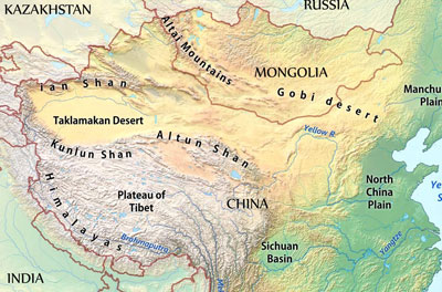
The Plateau of Tibet is the largest and highest in the world and is known as the Roof of the world. Asia is the birthplace of major religions of the world – Christianity, Islam, Hinduism, Judaism, Taoism, etc.
The population of Asia constitutes 62 percent of world’s population.
Africa
It is the second largest continent of the world. It is bounded by the Mediterranean Sea in North-West, Red Sea in the North, Indian Ocean in the South, Arabian Sea in the East and Atlantic Ocean in the West. Area is 30,221,532 sq. km., which is about 20.4% of the world’s total land area. Its northernmost point is Cape Blanc (in Tunisia) and the southernmost point is Cape Agulhas (in South Africa).
Its highest point is Mount Kilimanjaro (5895 m.) in Tanzania the lowest point is Lake Assal (153 m below sea level) in Djibouti. Important mountain ranges are Ahaggar, Atlas, Drakensberg, Tibesti, etc. Important deserts are Sahara, the Kalahari and the Namib Desert; Sahara is the largest desert of the world.
Important rivers are the Nile, the Zaire, the Niger and the Zambezi. The Nile is the longest river in the world. Important waterfalls are the Victoria Falls on Zambezi and Boyoma Falls on Zaire River.
Population is more than 900,000,000 which is about 14% of the world’s total population. Many Languages are spoken in Africa. Arabic is spoken by the maximum along the Swahili, Bantu, Zulu, English, etc.
Climate is predominantly equatorial type and tropical grassland type, as almost the entire Africa lies in the Torrid Zone.
Largest lakes are Lake Victoria, Lake Tanganyika and Lake Nyasa. From Victoria originates the river Nile.
Four largest countries in the decreasing order of areas are Sudan, Algeria, Zaire, and Libya. Four most populous countries in descending order are Nigeria, Egypt, Ethiopia, and Zaire.
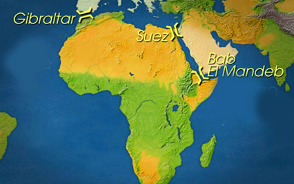
The three points where Africa almost touches Eurasia are Gibraltar, Suez, and Bab-el-Mandeb.
The country having highest death rate and least life expectancy in the world is Sierra Leone, which is in Africa only.
Important tribes are Bantus, Berbers Hausas, Masai, Pygmies, Hottentots, Bushmen, Tuaregs, Kikuyus, etc.
North America
It is the third largest continent of the world. It is bounded by the Pacific Ocean on the West, Atlantic Ocean on the East, Arctic Ocean on the North and Caribbean Sea and Panama Canal in the South.
Important mountain ranges are Alaska, Aleutian, Appalachians, Brooks, Cascade, Coast, Rockies, Sierra Nevada, Sierra Madre, etc. Highest peak is Mt. McKinley (6194 m.). Lowest Point is the Death Valley (86 m. below sea level). Largest lakes arranged from West to East are Superior, Michigan, Huron, Erie, and Ontario. Out of these only Michigan lies entirely in USA. Others are shared by USA with Canada.
Important rivers are Colorado, Columbia, Mackenzie, Mississippi, Missouri, St. Lawrence, etc.
Important dam is the Hoover dam on Colorado River. It is the highest dam in the world. Area is 24,490,000 sq. km.
Its population is more than 514,600,000. Diverse climatic types are found in North America. Important languages are English, Spanish and French.
The major part of Canada has Taiga and Tundra types of climate. Wheat is the most important crop here.
It is the fourth largest continent of the Earth. It is situated West of Atlantic Ocean, East of Pacific Ocean, South of North America and North of Antarctica.
The longest mountain range of the world, Andes, is located on the western coast of South America. The highest peak of America is Mt. Aconcagua (6959 m.).
The largest river of the world, Amazon, flows through South America. The highest waterfall of the world, Angel Falls, is in Venezuela in South America. They are on Orinoco River. The highest freshwater lake of the world, Titicaca, is in Bolivia in South America.
Major deserts are Atacama in Chile, and Patagonia in Argentina. Llanos and Campos are the Savanna grasslands in South America.
Selvas are the equatorial rainforests of Amazon basin. Cinchona trees are found in South America which is used to make quinine, the medicine used to cure Malaria.
Though the official language in most of the countries is Spanish, the official language of Brazil is Portuguese.
Countries in descending order of size are Brazil, Argentina, Peru, Columbia etc. Countries in descending order of population are Brazil, Columbia, Argentina, Peru, etc.
Trans-Andean railways connect Buenos Aires and Valparaiso. Kourou, the French satellite launching station is in French Guyana in South America. The Driest place on earth is Iquique in the desert, Chile.
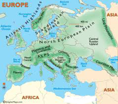
Europe
The Second smallest continent after Australia (area-wise), while population-wise, Europe is at the second spot after Asia.
It is surrounded by the Arctic Ocean in the North, the Black Sea and the Mediterranean Sea in the South, the Atlantic Ocean in the West and Ural mountains in the East. It is separated from Africa by the Strait of Gibraltar.
Important mountains are Alps, Apennines, Balkans, Carpathians, Caucasus, Pyrenees, Urals, etc. The Highest peak is the El’brus (5633 m.). Major Rivers are Danube, Dnieper, Don, Elbe, Po, Rhine, Rhone, Seine, Thames, Tiber, Volga, etc.
Major religions are Christianity, Islam and Judaism.
The climate is mild and generally humid in the West and North-West. Mediterranean type in South end cool humid with cool summers in the east.
Yugoslavia, Bulgaria, Greece, Romania, and Albania are collectively called Balkan states. Iceland, Norway, Sweden and Denmark are collectively known as Scandinavia. The world’s northerly capital is Reykjavik of Island.
Australia
Australia is the smallest continent of the world. It lies entirely in the Southern Hemisphere. The tropic of Capricorn runs almost through middle of this continent. Australia was discovered by Captain James Cook, an English seaman, 1770.
Most of Australia is dry. The Eastern, North-Eastern and South-Western parts of the country come in the way of winds from the sea and thus receive very heavy rainfall.
The Gibson, the Simpson, the Great Victorian and the Great Sandy deserts constitute the Great Australian Desert. The highest peak of Australia is Mt. Kosciusko. Largest lake in Australia is Eyre.
Australia is mainly an agricultural country. Wheat is the most important food crop. A variety of fruits-both temperate and tropical, ager also grown.
Australia has considerable mineral wealth. It has large reserves of coal, iron-ore, bauxite, manganese and tin. Some petroleum and natural gas is also found.
Australia makes several products from its agriculture and animal raw materials. They are cotton and woolen textiles, sugar, condensed and powdered milk, butter, cheese and meat. Australia has the largest number of sheep in the world. Marine is the most important breed of wool producing sheep.
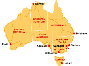
B.Sc. M.A. Ph.D.: It is an interesting acronym for the clockwise arrangement of the Australian coastal cities. The cities are Brisbane, Sydney, Canberra, Melbourne, Adelaide, Perth, and Darwin.
The Great Barrier Reef: It is the world’s longest coral reef, it is located in North-East of Australia.
The Australian States in decreasing order of population is New South Wales, Victoria, Queensland, and Western Australia. The largest State of Australia is Western Australia. The Australian cities in decreasing order of population are Sydney, Melbourne, and Brisbane.
Australasia stands for Australia and New Zealand. The biggest city in New Zealand is Auckland, while the capital is Wellington. The first European to discover New Zealand was Able Tasman.
Antarctica
Antarctica is the fifth largest continent of the world. It is at south pole mostly ice covered and uninhabited by humans. However one can find rich wildlife there. Area of Antarctica is around 14 million sq. km.
An earthquake (also known as a quake, tremor or temblor) is the result of a sudden release of energy in the Earth’s crust that creates seismic waves. The seismicity, seismism or seismic activity of an area refers to the frequency, type and size of earthquakes experienced over a period of time.
Earthquakes are measured using observations from seismometers. The moment magnitude is the most common scale on which earthquakes larger than approximately 5 are reported for the entire globe.
At the Earth’s surface, earthquakes manifest themselves by shaking and sometimes displacement of the ground. When the epicentre of a large earthquake is located offshore, the seabed may be displaced sufficiently to cause a tsunami. Earthquakes can also trigger landslides, and occasionally volcanic activity.
Earthquakes are caused mostly by rupture of geological faults, but also by other events such as volcanic activity, landslides, mine blasts, and nuclear tests. An earthquake’s point of initial rupture is called its focus or hypocenter. The epicentre is the point at ground level directly above the hypocenter.
There are three main types of fault, all of which may cause an interplate earthquake: normal, reverse (thrust) and strike-slip. Normal and reverse faulting are examples of dip-slip, where the displacement along the fault is in the direction of dip and movement on them involves a vertical component. Normal faults occur mainly in areas where the crust is being extended such as a divergent boundary.
Reverse faults occur in areas where the crust is being shortened such as at a convergent boundary. Strike-slip faults are steep structures where the two sides of the fault slip horizontally past each other; transform boundaries are a particular type of strike-slip fault. Many earthquakes are caused by movement on faults that have components of both dip-slip and strike-slip; this is known as oblique slip.
Reverse faults, particularly those along convergent plate boundaries are associated with the most powerful earthquakes, megathrust earthquakes, including almost all of those of magnitude 8 or more. Strike-slip faults, particularly continental transforms can produce major earthquakes up to about magnitude 8. Earthquakes associated with normal faults are generally less than magnitude 7.
Earthquakes often occur in volcanic regions and are caused there, both by tectonic faults and the movement of magma in volcanoes. Such earthquakes can serve as an early warning of volcanic eruptions, as during the Mount St. Helens eruption of 1980. Earthquake swarms can serve as markers for the location of the flowing magma throughout the volcanoes. These swarms can be recorded by seismometers and tiltmeters (a device that measures ground slope) and used as sensors to predict imminent or upcoming eruptions.
Earthquakes can be recorded by seismometers up to great distances because seismic waves travel through the whole Earth’s interior. The absolute magnitude of a quake is conventionally reported by numbers on the moment magnitude scale (formerly Richter scale, magnitude 7 causing serious damage over large areas), whereas the felt magnitude is reported using the modified Mercalli intensity scale (intensity II–XII).
Every tremor produces different types of seismic waves, which travel through rock with different velocities:
To provide the best experiences, we use technologies like cookies to store and/or access device information. Consenting to these technologies will allow us to process data such as browsing behavior or unique IDs on this site. Not consenting or withdrawing consent, may adversely affect certain features and functions.
Functional
Always active
The technical storage or access is strictly necessary for the legitimate purpose of enabling the use of a specific service explicitly requested by the subscriber or user, or for the sole purpose of carrying out the transmission of a communication over an electronic communications network.
Preferences
The technical storage or access is necessary for the legitimate purpose of storing preferences that are not requested by the subscriber or user.
Statistics
The technical storage or access that is used exclusively for statistical purposes.The technical storage or access that is used exclusively for anonymous statistical purposes. Without a subpoena, voluntary compliance on the part of your Internet Service Provider, or additional records from a third party, information stored or retrieved for this purpose alone cannot usually be used to identify you.
Marketing
The technical storage or access is required to create user profiles to send advertising, or to track the user on a website or across several websites for similar marketing purposes.