‘Clouds’ are a sufficiently distinctive result of condensation to be discussed in some detail. They consist of tiny particle, either of water or of ice, which floats in masses at various heights above sea-level, ranging from ground level (where they occur in the form of) to the highest wisps at 40,000 feet.
“Cloud is the mass a mass of tiny visible particles, usually of water (0.0008 to 0.0024 inches in diameter), sometimes of ice, which form by condensation on nuclei such as dust and smoke particles, salt, pollen and negative ions. The float in masses at the various height above sea level, ranging from near the ground (fog or mist) to over 40,000 feets.”
Read Also: Why do rain cloud appear black ?
Clouds are classified:
(I) By Height

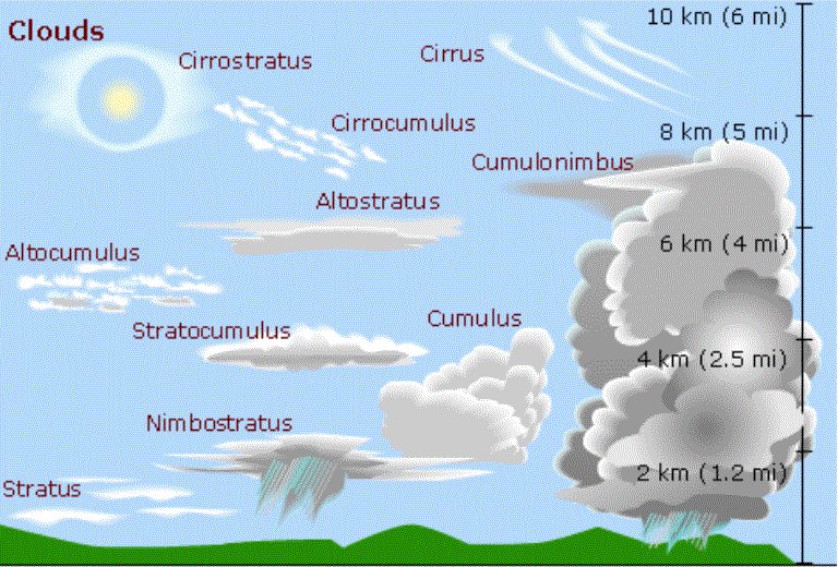
- Low cloud upto 8,000 feet
- Medium cloud at 8,000-20,000 feet
- High cloud at 20,000-40,000 feet
(II) By Form
- Feathery or fibrous (Cirrus)
- Globular or heaped (Cumulus)
- Sheet of layer (Stratus)
Other types (see individual names) are distinguished by the combination of the three form names, by adding the suffix ‘Alto’ to indicate height, and ‘Nimbus’ to signify falling rain, thus forming ten main generally. Other variations are:
- Lens-shaped Lenticularis
- Turret shaped Castellatus
- Breast shaped Mammatus
- Tattered ragged clouds (Fracto-) and many more
NAME |
HEIGHT |
DESCRIPTION |
REMARKS |
| stratus | 0-1500ft | Whitish, gray layer, often covering hills. | May give drizzle. |
| cumulonimbus | 1500-6500ft | Huge towers of heavy dense clouds. The tops are flat, usually spreading. | Often bring showers and thunder. |
| cumulus | 1500-6500ft | Detached dense clouds with sharp outlines and rising domes, mounds or towers. | Associated with sunny weather and scattered showers. |
| stratocumulus | 1500-6500ft | Grey or white rolling patches or sheets. | Bring dull weather, sometimes with drizzle. |
| nimbostratus | 3000-10000ft | Dark gray cloud layer, usually diffused by rain or snow. | Ragged patches of stratus may occur below the layer. |
| altostratus | 3000-10000ft | Flat, thick blue-gray sheet. | Indicates rain or snow if associated with cirrostratus. |
| altocumulus | 6500-23000ft | White or gray rounded clouds, | Usually break up leaving good weather. |
| cirrostratus | 16500-45000ft | A transparent milky veil which can be fibrous or smooth. | Indicates rain later. |
| cirrocumulus | 16500-45000ft | Thin rippled sheets of rounded clouds. | Form on the edge of unsettled weather. |
| cirrus | 16500-45000ft | Fibrous or hair like clouds with a silky sheen. | An indication of bad weather to follow with strong winds at the cloud level. |
| nacreous | Mother of pearl clouds found very high over mountains, usually lit by sunlight. | ||
| noctilucent | Very high bluish clouds, probably cosmic dust. Normally only seen in high latitudes. |
Don’t Miss: