Home Blog Page 334

Erosion

1
Erosion

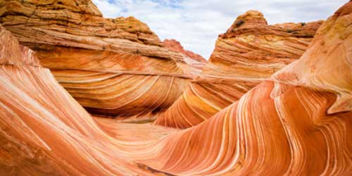
Erosion is the wearing away of the land by forces such as  water, the wind, and ice. Erosion has helped to form many interesting features of the Earth‘s surface including mountain peaks, valleys, and coastlines.

There are many different forces in nature that cause erosions. Depending on the type of force, erosions can happen quickly or take thousands of years. The three main forces that cause erosion are water, the wind, and ice.

Must Read: Water Resources of India

Erosion by Water

Water is the main cause of erosions on Earth. Although water may not seem powerful at first, it is one of the most powerful forces on the planet. Here are some of the ways that water causes erosion:

  • RainfallRainfall can cause erosions both when the rain hits the surface of the Earth, called splash erosions, and when raindrops accumulate and flow like small streams.
  • RiversRivers can create a significant amount of erosions over time. They break up particles along the river bottom and carry them downstream. One example of river erosion is the Grand Canyon which was formed by the Colorado River.
  • Waves – Ocean waves can cause the coastline to erode. The sheer energy and force of the waves cause pieces of rock and coastline to break off changing the coastline over time.
  • Floods – Large floods can cause erosions to happen very quickly acting like powerful rivers.

Also Read: Water Cycle

Erosion by Wind

The Wind is a major type of erosion, especially in dry areas. The Wind can erode by picking up and carrying loose particles and dust away (called deflation). It can also erode when these flying particles strike the land and break off more particles (called abrasion).

Erosion by Glaciers

Glaciers are giant rivers of ice that slowly move carving out valleys and shaping mountains.

Also Read: Monsoon, Floods and Droughts

Other Forces

  • Living organisms – Small animals, insects, and worms can add to erosions by breaking up the soil so it is easier for the wind and water to carry away.
  • Gravity – The force of gravity can cause erosions by pulling rocks and other particles down the side of a mountain or cliff. Gravity can cause landslides which can significantly erode an area.
  • Temperature – Changes in temperature caused by the Sun heating up a rock can cause the rock to expand and crack. This can cause pieces to break off over time and lead to erosions.

Human activity has increased the rate of erosions in many areas. This happens through farming, ranching, cutting down forests, and the building of roads and cities. Human activity has caused about one million acres of topsoil to erode each year.

Have a Look at: Minerals: India’s Mineral Resources

Erosion Control

There are things that can be done to limit the amount of erosions caused by human activity. This includes planting trees around farmland to protect it from the wind, moving herds around so that grasslands will grow back, and planting new trees to replace the ones cut down.

Interesting Facts about Erosion

  • The word erosion comes from the Latin word “erosion em” which means “a gnawing away.”
  • Scientists estimate that the Colorado River has been eroding the Grand Canyon for many millions of years.
  • Wind erosions can cause huge dust storms.
  • The fastest glacier ever moved over seven miles in three months.
  • Fossils in sedimentary rock are often uncovered by erosions.

Don’t Miss:

World’s 10 Greatest Ocean or Seas, Deserts, and Mountains

Water Resources in India

Types of Indian soils and their distribution

Topography

Water Cycle

0
Water Cycle

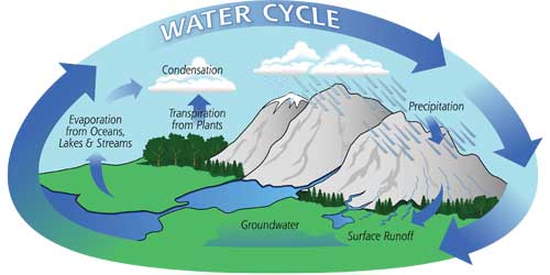
The water cycle is a way that water moves all around the Earth. It never stops and doesn’t really have a beginning or an end. It’s like a big circle. We’ll describe it by starting with water that’s on land. For example, water in the ocean or a lake. Some water on the surface of the ocean will evaporate due to heat from the sun. When it evaporates it turns into vapor water and goes up into the atmosphere.

This vapor water gets together with a lot of other vapor water and turns into clouds. Clouds move about the earth with the weather and once they are so full of water they drop the water to Earth in some form of precipitation. It could be rain, snow, sleet, or hail. When the water hits the earth it may fall right back into the ocean or feed a flower or be snow on the top of a mountain. Eventually, this water will evaporate and start the whole cycle again.

Must Read: Water Resources of India

There are three main ways that water on land turns into vapor:

Evaporation – This is the main process by which water goes from the ground to vapor in the atmosphere. Around 90 percent of the water vapor in the atmosphere got there through evaporation. Evaporation takes place only on the water’s surface. It takes energy in the form of heat. Hot water will evaporate more easily than cold water. The sun provides a lot of the energy for evaporation in the water cycle, primarily causing evaporation from the surface of the ocean.

Sublimation – This is when water moves directly to vapor from ice or snow without ever melting into water. Good conditions for sublimation to occur is when ice or snow is in very cold conditions, but it is windy and the sun is shining.

Transpiration – Transpiration is when plants release water to their leaves that then evaporates into vapor. Plants will release a lot of water as they grow. Around 10 percent of the water vapor in the atmosphere is estimated to come from transpiration.

Also Read: Water Resources in India

Water in the atmosphere

We see water in the atmosphere in the form of clouds. There is a small amount of water even in clear skies, but clouds are where water has started to condense. Condensation is the process of water vapor becoming liquid water. Condensation is a major step in the water cycle. The atmosphere helps to move water around the world. It takes water that evaporated from the ocean and moves it over land where clouds and storms form to water plants with rain.

Precipitation

Precipitation is when water falls from the atmosphere back to land. Once enough water gathers in a cloud droplet of water will form and fall to the earth. Depending on the temperature and weather this could be rain, snow, sleet, or even hail.

Water storage

A lot of the Earth’s water does not take part in the water cycle very often. Much of it is stored. The Earth stores water in a number of places. The ocean is the largest storage of water. Around 96 percent of the Earth’s water is stored in the ocean. We can’t drink the salty ocean water, so fortunately for us, freshwater is also stored in lakes, glaciers, snow caps, rivers, and below the ground in ground water storage.

Also, Read:

Hydrosphere Facts

Global warming

Ecology and Environment

Oxygen Cycle

Ill effect of green revolution on India.

1

Ill effects of green revolution on India can be summerised as below:

Land degradation caused by:

  • water logging
  • salinization of the soil
  • desertification and water scarcity
  • destroying water resources
  • destruction of soil fertility
  • micronutrient deficiency
  • soil toxicity, by high use of pesticides and chemical fertilizers
  • biomass reduction used for fodder and organic manure

Genetic erosion caused by:

Mixtures and rotation of diverse crops like wheat, maize, millets, pulses and oil seeds were replaced by monocultures of wheat and rice

The introduced wheat and rice varieties reproduced over large-scale as monocultures came from a very narrow genetic base, compared to the high genetic variability in the populations of traditional wheat or rice plants.

Other negative ecological impacts:

  • Greenhouse effect with atmospheric pollution
  • Pesticide contamination of soil, water and animal life
  • Loss of common lands under forests and pastures

Unsafe conditions

Nutritional imbalances as a result of the reduction of pulses, oilseeds, millets and other crops.

As a result of the Green Revolution agriculture of many different crops was replaced by mainly rice and wheat. Owing to this the supply of local produced food which contains all needed proteins, minerals and vitamins, decreased. If people want this crops who were produced outside the region at least the prices increased because of the transportcosts.

Pesticide contamination of food, water, and human life.

As a result of the much higher use of pesticides since 1965, food and water got contaminated.

Building dams with by heavy rainfall can lead to floods.

Famous Explorers and Travellers

0
Vasco da Gama
Vasco da Gama
  • Marco Polo (1254-1324):

Italian traveler Marco Polo was one of the first European to visit China and other far eastern territories. However, his reports were not believed but he encouraged the idea of trading with the East. His father and uncle were a merchant which inspired Polo to overcome the deep concepts of appraising, foreign currency and handling cargo ships.

  • John Cabot (1450-98):

Italian-born explorer John Cabot was employed by British merchants to seek a western route to Asia. During his travels, he discovered parts of the northeast coast of America. He was also sponsored by the Great Britain to start an expedition for exploring the Atlantic.

Read Also: World’s Earliest Civilizations Egyptian, Sumerian, Indus Valley and Phoenician

  • Christopher Columbus (1451-1506):

This Genoese colonizer discovered North, Central and South America and the islands of West Indies. It was Columbus who established the string between indigenous Americans and Europeans. As a phenomenon of culture and civilization, Columbus will be always remembered for discovering the “New World”.

  • Vasco da Gama (1460-1524):

Considered as the greatest hero in the European age of discovery, Portuguese explorer Vasco da Gama traveled round the Cape of Good Hope and up the East coast of Africa and later discovered a trade route to India. After mastering in the field of mathematics and navigation he became the governor of Portuguese India in 1524.

  • Ferdinand Magellan (1480-1521):

Magellan was a Portuguese explorer who led the first voyage around the world. He discovered the Strait of Magellan, near the tip of South America. He was born in Sabrosa but later adopted the nationality of Spain to serve King Charles I in order to explore the westward route to the Spice Island.

  • Abel Tasman (1603-59):

This Dutchman was an aesthetic voyager and is notable for exploring Australia, New Zealand and Van Diemen’s Land (later called Tasmania). With his ships Heemskerck and Zeehaen , Tasman led the exploring expedition towards North Pacific with the object to obtain knowledge of all undiscovered beaches in the world.

Also, Read: Marco Polo  An Italian Travelled China and the Far East

  • Henry Hudson (1550-1611):

Henry Hudson was an English navigator who searched for a Northwest Passage (a route to the east by traveling north of America) and discovered Hudson’s Bay. He is also credited to discover the area around modern New York City while exploring the route to Asia via west.

  • James Cook (1728-79):

Famous British Captain James Cook led several major expeditions. He explored the coasts of Australia, New Zealand, and North America. An epitome in the area of geographical exploration, Captain Crook was killed in 1779 by Hawaiians during his third exploratory navigation.

  • David Livingstone (1813-73):

Livingstone was a Scottish missionary and explorer of Africa. He discovered and named the Victoria Falls after Queen Victoria. Encourager of commercial empire, Livingstone was born in a protestant family and his father was much institutionalized to his beliefs.

  • Sir Richard Burton (1821-90):

Son of a British army officer, Sir Burton is best known for exploring Arabia and Lake Tanganyika in Africa. Strictly denying the colonial policies, he served for seven years in India as a captain in the army of “East India Company”. This controversial poet is also credited for translating “One Thousand And One Nights” .

Don’t Miss:

10 people who changed the world

India crossed a new milestone in Space Technology

Geographical Indication (GI) Status

9
Geographical Indication

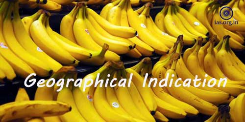
Recently, Geographical Indication (GI) status has been allowed to Kadaknath Chicken of Madhya Pradesh; earlier Chengalikodan banana variety from Thrissur district or Kerala. This banana is famous for its distinct taste, bunch shape and fruit colour. The nature fruits are pale yellow that, on ripening, change into golden yellow with red patches. The crop is principally cultivated in organic mode and the crop duration is 13-14 months and is chiefly grown in Thrissur district of Kerala.

What is a Geographical Indication (GI)

A GI is a sign that is used on products that have a distinct geographical origin due to which these products acquire such reputations. In order to being categorized as a GI, a sign must identify a product as originating in a particular place.

Since the qualities, characteristics, or reputation depend on the geographical place of production, there is an unambiguous link between the product and its original place of production. GI is also a type of Industrial Property Rights (IPR).

Read Also: World Trade Organization (WTO) and India’s Stand

Origin and Legal Framework of GI

The origin of GI can be tracked to various International agreements. Articles 1 (2) and 10 of the Paris Convention for the Protection of Industrial Property cover geographical indications as an element of IPR. They are also shielded under Articles 22 and 24 of the Trade-Related Aspects of Intellectual Property Rights (TRIPS) Agreement TRIPS was the part of the Agreement finalizing the Uruguay Round of GATT negotiations.

India, as a member of World Trade Organization (WTO), introduced the Geographical Indications of Goods (Registration and Protection) Act, 1999. This GI Act was enacted in 2003 that finally came into force with effect from 15th September 2003.

GI, functioning as a signaling tool, helps producers in differentiating their products from competing products in the market. It helps producers in building a reputation and goodwill around their products which generally fetch a premium price.

The Geographical Indications Act 2003 is administered by the Controller General of Patents, Designs and trademarks. This Controller General is also the Registrar of Geographical Indications. The Geographical Indications Registry is situated in Chennai.

Types of Products seeking GI

Geographical Indications are solely used for industrial products, agricultural products, handicrafts, foodstuffs, and wine spirit drinks.

Rights provided by GI

A Geographical Indications Right empowers those who use the ‘indication’ to prevent its use by a third party whose product does not conform to the applicable norms.

However, a shielded geographical indication does not mean that the holder of the GI can prevent someone from making a product using the same techniques as those framed in the standards for the indication.

Validity Period of GI

The Registration for Geographical Indications is not bonded to a specific period of validity. In fact, the protection for a Registered Geographical Indication remains valid till the registration is cancelled.

GI registered as collective and certification marks, are usually protected for a renewable ten-year periods.

Also Read: International Red Cross and Red Crescent Movement

Who can use GI?

Producers, of the Geographical defined area, who meet the specific conditions of production for the product, have the right to use the Geographical Indication.

Difference between GI and Trademark

While GIs recognize a good as originating from a particular place, the trademark identifies it a good or service as originating from a particular company. The name that is used as a geographical indication is generally predetermined by the name of the GI area while, in the case of trademark , it usually uses a recognizable sign, design, or expression.

Any person, who produces the goods according to specified and standards, can use GI; while trademark is assigned to anyone, anywhere in the world, because it is related to a specific company and not to a particular place.

Some recent GI tags awarded to:

Bangalore Rose Onion grows in Bangalore and its surrounding areas. It is famous for its high demand compared to other varieties.

Kaipad Rice that is cultivated in the blackish water tracts of northern parts of the Kerala.

Dahrmavaran Saris comes from Dharmavaran, a cluster of weavers in Anantpur, Andhra Pradesh. The Saris have broad solid colour borders with contrast pallus woven with brocaded gold patterns.

The first agricultural product in India to be accorded with GI tag is Darjeeling Tea. There are about 200 unique products registered as GIs in India.

Don’t Miss: RCEP Ultimatum : Cut Tariffs or Leave FTA talks