
Home Blog Page 335

Geographical Indication (GI) Status

9
Geographical Indication

Recently, Geographical Indication (GI) status has been allowed to Kadaknath Chicken of Madhya Pradesh; earlier Chengalikodan banana variety from Thrissur district or Kerala. This banana is famous for its distinct taste, bunch shape and fruit colour. The nature fruits are pale yellow that, on ripening, change into golden yellow with red patches. The crop is principally cultivated in organic mode and the crop duration is 13-14 months and is chiefly grown in Thrissur district of Kerala.

What is a Geographical Indication (GI)

A GI is a sign that is used on products that have a distinct geographical origin due to which these products acquire such reputations. In order to being categorized as a GI, a sign must identify a product as originating in a particular place.

Since the qualities, characteristics, or reputation depend on the geographical place of production, there is an unambiguous link between the product and its original place of production. GI is also a type of Industrial Property Rights (IPR).

Read Also: World Trade Organization (WTO) and India’s Stand

Origin and Legal Framework of GI

The origin of GI can be tracked to various International agreements. Articles 1 (2) and 10 of the Paris Convention for the Protection of Industrial Property cover geographical indications as an element of IPR. They are also shielded under Articles 22 and 24 of the Trade-Related Aspects of Intellectual Property Rights (TRIPS) Agreement TRIPS was the part of the Agreement finalizing the Uruguay Round of GATT negotiations.

India, as a member of World Trade Organization (WTO), introduced the Geographical Indications of Goods (Registration and Protection) Act, 1999. This GI Act was enacted in 2003 that finally came into force with effect from 15th September 2003.

GI, functioning as a signaling tool, helps producers in differentiating their products from competing products in the market. It helps producers in building a reputation and goodwill around their products which generally fetch a premium price.

The Geographical Indications Act 2003 is administered by the Controller General of Patents, Designs and trademarks. This Controller General is also the Registrar of Geographical Indications. The Geographical Indications Registry is situated in Chennai.

Types of Products seeking GI

Geographical Indications are solely used for industrial products, agricultural products, handicrafts, foodstuffs, and wine spirit drinks.

Rights provided by GI

A Geographical Indications Right empowers those who use the ‘indication’ to prevent its use by a third party whose product does not conform to the applicable norms.

However, a shielded geographical indication does not mean that the holder of the GI can prevent someone from making a product using the same techniques as those framed in the standards for the indication.

Validity Period of GI

The Registration for Geographical Indications is not bonded to a specific period of validity. In fact, the protection for a Registered Geographical Indication remains valid till the registration is cancelled.

GI registered as collective and certification marks, are usually protected for a renewable ten-year periods.

Also Read: International Red Cross and Red Crescent Movement

Who can use GI?

Producers, of the Geographical defined area, who meet the specific conditions of production for the product, have the right to use the Geographical Indication.

Difference between GI and Trademark

While GIs recognize a good as originating from a particular place, the trademark identifies it a good or service as originating from a particular company. The name that is used as a geographical indication is generally predetermined by the name of the GI area while, in the case of trademark , it usually uses a recognizable sign, design, or expression.

Any person, who produces the goods according to specified and standards, can use GI; while trademark is assigned to anyone, anywhere in the world, because it is related to a specific company and not to a particular place.

Some recent GI tags awarded to:

Bangalore Rose Onion grows in Bangalore and its surrounding areas. It is famous for its high demand compared to other varieties.

Kaipad Rice that is cultivated in the blackish water tracts of northern parts of the Kerala.

Dahrmavaran Saris comes from Dharmavaran, a cluster of weavers in Anantpur, Andhra Pradesh. The Saris have broad solid colour borders with contrast pallus woven with brocaded gold patterns.

The first agricultural product in India to be accorded with GI tag is Darjeeling Tea. There are about 200 unique products registered as GIs in India.

Don’t Miss: RCEP Ultimatum : Cut Tariffs or Leave FTA talks
Solar Eclipse – Everything You Need to Know

2
solar eclipse

On Wednesday some parts of India witnessed a partial solar eclipse. It was the first such phenomenon of year 2016.

What is a Solar Eclipse?

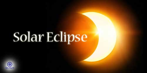
Human beings experience a solar eclipse on Earth when the Moon, while moving in its orbit, comes in its orbit between Earth and the Sun. it is a natural event that is also known as an occultation. As the lunar orbit is oval and sloped, with respect to Earth’s orbit, one can only see up to 5 eclipses each year.

When an eclipse happens, the Moon’s shadow passes across the surface of Earth. The Moon’s shadow has two parts: the dark umbra (darkest shadow of the Moon), and the lighter penumbra (the lighter path of the Moon’s shadow).

Types of Solar Eclipse

There are three types of it:

  • Total
  • Annular
  • Partial

Also Read: Our Solar System

Total Solar Eclipse:

In a total solar eclipse, the Moon blocks the entire solar disk (the surface of the Sun). In this event, the narrowest part of the path (where the Moon, while shedding its Umbra, completely blocks the surface of the Sun) is known as the “zone of totality.”

In this zone of totality one sees a darkened Sun (frequently termed as a “hole in the Sky”) with the shadowy Shine of the solar corona reaching out to space. As sunrays glow out through valleys on the lunar surface one can witness a phenomenon known as “Bailey’s Beads” that happen frequently.

During the event of total solar eclipse (TSE) one can also witness prominences, loops and flares during totality. It is imperative here to point out that a TSE is the only time when it is safe to look directly at the Sun. in all other solar eclipses (even in a partial one) one needs special solar filters to protect one’s eyes from burning.

Annular Solar Eclipse:

This kind of eclipse occurs when the Moon remains farther away in its orbit than usual and becomes unable to completely cover the surface of the Sun. during the event, a bright ring of sunlight glows around the Moon. As the word annular has its origin in the Latin word annulus meaning “ring”, this kind of eclipse has been termed an annular eclipse.

The annular solar eclipse can last from 5 or 6 minutes to up to 12 minutes. Since enough bright sunlight releases during this period of annularity, one cannot look at the Sun directly and needs eye protection to watch the event.

Must Read: Solar System: Some Important Facts

Partial Solar Eclipse:

An event of a partial solar eclipse happens when Earth passes through the lighter part of the Moon’s shadow (lunar penumbra) as the Moon comes between Earth and the Sun. in this event the Moon does not completely cover the surface of the Sun, as seen from Earth. During a partial solar eclipse one might see anything between from a small scrap of the Sun being blotted out to a nearly total eclipse as it depends entirely on one’s location.

Safety Notes for Watching a Solar Eclipse:

In order to avoid serious eye damage that can even lead to the blindness because of the burning of eyes, one must never look at the Sun directly. To watch the eclipse safely one must use approved filters such as projecting sunlight through a telescope and into a white piece of paper or cardboard. One must never look at the Sun through a telescope that does not have proper filter.

Some Facts

  • The reason for the occurrence of the Solar Eclipse is that the distance between the Earth and the Sun is about 400 times the Moon’s distance from the Sun and the diameter of the Sun is approximately 400 times larger than the Moon’s.
  • A total solar eclipse can occur once every 1 to 2 years. This makes it a very rare event.
  • The width of the “zone of totality” is usually about 160 km and can sweep across an area of about 10,000 miles of Earth’s surface.
  • If any planets remain in the sky at the time of a total solar eclipse, they can be watched as points of light.
  • Almost same eclipses occur after 18 years and 11 days. This period of 223 synodic months has been termed as saros.
  • Conditions in the zone of totality, during a total solar eclipse, can change quickly. Air temperature drops and immediately the area becomes dark.

Next solar eclipse will occur on 1 September 2016.

Don’t Miss: General Geography Compendium – Earth for Competitive Exams

Jupiter; The Largest Planet of Solar System

3
jupiter

Apposition of Jupiter

On 8th March 2018, after the sunset to almost whole night in India, people witnessed geographical phenomena called Apposition of Jupiter after 13 years. This event occurs when Earth comes between Jupiter and the Sun almost exactly on a line from one another.

Jupiter is the largest planet in the Solar System. It is the fifth planet from the Sun. it is a gas giant planet, along with Saturn. Jupiter has a mass of one-thousandth that of the Sun but is two and a half times massive them all the other planets in the entire Solar System. Since it is made primarily of gasses, it is known as a “gas giant”.

Jupiter’s Moons

Jupiter has a cluster of at least 67 moons, the largest number of natural satellites around any of the planets, in orbit around it. Amongst these, the four largest moons of Jupiter are Ganymede, Callisto, Io and Europa. Since they were discovered by Galileo Galilei, they are known as the Galilean moons.

Also Read: Solar Eclipse – Everything You Need to Know

Ganymede, discovered in 1610, is Jupiter’s largest Moon. It is also the largest Moon in the Solar System. It is larger than the planet Mercury. If it were not orbiting as Jupiter’s Moon, it could have been considered a dwarf planet. It is named after the mythical Greek son of a king, who was carried to the sky by Zeus pretending to be an eagle.

Callisto is the second largest Moon of Jupiter and is nearly the size of Mercury. It was also discovered in 1610. It is a half-rocky, half- icy Moon. The surface of this Moon contains rocky particles carbon dioxide, hydrocarbon compounds, water ice and silicate dust.

Europa, discovered in 1610, is the smallest of Jupiter’s Galilean Moons. It is named after a woman in Greek mythology, who was daughter of a king. She was believed to be one of Zeus’ many lovers and was made the queen of Crete. It is nearly the same size as Earth’s Moon. Its orbit is nearly circular.

Facts About Jupiter

The Sightings of Jupiter was first recorded by the ancient Babylonians around 7th or 8th century BC. It is named after the king of Roman gods. To Greeks, it represented the god of thunder – Zeus. To the Mesopotamians it represented the god Marduk and the patron of the city of Babylon. Germanic tribes saw this planet as Donar or Thor.

Also Read: Valuable facts to know about Mars Planet

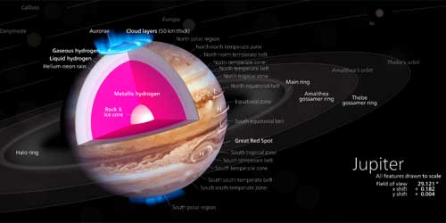
Jupiter has a thin ring system:

Whose rings are made up mainly of dust particles ejected from some of Jupiter’s smaller worlds during impacts from incoming comets and asteroids. It has unique cloud features as its upper atmosphere is divided into cloud belts and zones. They are composed primarily of ammonia crystals, sulfur, and mixtures of the two compounds.

Jupiter is the fourth brightest object in the solar system and is one of the five planets visible to the naked eye from Earth. Only the Sun, Moon and Venus are brighter than Jupiter.

Jupiter’s interior is made of rock, metal, and hydrogen compounds. The massive atmosphere is composed primarily of hydrogen. There are layers of compressed hydrogen gas, liquid metallic hydrogen, and a core of ice, rock, and metals below its atmosphere.

The Great Red Spot is a huge storm on Jupiter that has raged for at least 350 years. It is so massive that it can envelop three Earth inside it.

Till date eight spacecraft have visited it: Pioneer 10 and 11, Voyager 1 and 2, Galileo, Cassini, Ulysses, and New Horizons missions. The Juno mission is in its way and will reach to Jupiter in July 2016.

Jupiter orbits the Sun once every 11.8 Earth years. From Earth, it appears to move slowly in the sky. It takes months to more from one constellation to another.

It has the shortest day among all the planets. It rotates on its axis once every 9 hours and 55 minutes. The rapid rotation, while giving it an oblate shape, flattens the planet slightly.

Don’t Miss: GS Quiz – Previous Year’s Questions from Geography

Winds and Their Types

1

Three broad categories of wind types are:

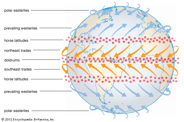
Regular Winds: e.g. Trade winds, Easterlies and Polar Easterlies

Prevailing Winds/ Planetary Periodical Winds: (which blow seasonally) Monsoon

Variable Winds: Cyclones and other local winds

planetary-winds

Also Read: Monsoon, Floods and Droughts

Trade Winds

Trade in German means ‘Track’. To blow ‘trade’ means ‘to blow steadily in the same direction and in a constant course’.

They blow from the sub-tropical high pressure belts towards the equatorial low pressure belt. Under the influence of the Coriolis force they blow from the north-east SW in the northern hemisphere and from the south-east NW direction in the southern hemisphere.

Westerlies

Blow from subtropical High pressure to sub-polar low pressure belt.

They blow in SW to NE direction in Northern hemisphere and NW and SE direction in Southern hemisphere.

In the northern hemisphere, land masses cause considerable disruption in the westerly wind belt. But between 40 degree and 60 degree south lies the almost unbroken ocean belt. Westerlies are strong and persistent here, giving rise to mariner’s expressions – Roaring Forties, Furious Fifties, and Shrieking Sixties.

Polar Easterlies

Move from high pressure poles to sub-polar low pressure area in east and west direction.

These are deflected by the Earth’s rotation to become east winds or polar easterlies.

Local Winds

Chinook: Hot dry wind in Rockies also called ‘snow eater’

Hoehn: Hot, dry wind in Alps

Khamsin: Hot, dry wind in Egypt

Sirocco: Hot, moist wind from Sahara to Mediterranean Sea.

Solano: Hot, moist wind from Sahara towards Iberian Peninsula

Hamattan: Hot dry wind blowing outwards from interior of West Africa also called Guinea Doctor.

Bora: Cold, dry wind blowing outward from Hungary to the north of Italy (near Adriatic Sea)

Mistral: Very cold wind, which blows down from the Alps, over France.

Zonda: Cold, dry wind blow in Argentina

Blizzard: Very cold wind in Tundra region

Brickfielder: Hot wind in Australia

Purga: Cold wind in Russian Tundra

Lavanter: Cold wind in Spain

Norwester: Hot wind in New Zealand

Santa Ana: Hot wind in South California in USA


You may also like:

Rainfall regions of India

Physical features of India: physiographic units

Water Resources of India

6
water resources of India

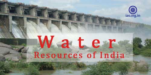
Water, our most precious resource, is limited and, naturally, unequally distributed. The stress on water resources of India is mounting up as the demand for water is increasing at an alarming speed because of the rapid growth of population, urbanization and industrialization.

In India the average annual water availability has been appraised as 1869 Billion Cubic Metres (BCM) and ground water 433 BCM.

It is the Ministry of water Resources that formulates policies and programmes for the development, regulation and judicious utilization of water.

Must Read: Water Resources in India

Chief Water Resources of India include:

Irrigation

Irrigation as a key component of water resources in India is vital for realizing full potential of agriculture sector of the country. In Areas where rainfall varies very much, the availability of irrigation makes the cultivation of crop more reliable and sustainable.

It is so the significance of the efficient utilization of water resources of India can hardly be ignored. Drought has become an annual phenomenon in India as the delayed arrival of monsoon generally reduces the agricultural returns. Apart from this, the winter crops are more or less dependent on irrigation, hence the need for the irrigation.

Irrigation in India has a history of thousand years, and currently in the field of irrigation India stands first in terms of total irrigated area.

Read Also: Water on the Earth

Canals

Canals are one of the oldest and most important water resources of India. However, Canal irrigation is largely limited to the States that form the Great plains of India: Bihar, West Bengal, Uttar Pradesh, Rajasthan, Uttrakhand, Haryana and Punjab) and the states that form the fertile plains of India: Andhra Pradesh, Madhya Pradesh, Karnataka, Odisha and Tamil Nadu.

Some of the important canals of the irrigation system of India are:

The Bari Doab canal; Indira Gandhi canal; Bhakhra canal, Eastern and Western Yamuna canals; the Ganga canal; Agra and Sharda canal; etc. Certain areas of the Thar Desert in the Indira Gandhi Command area, has been transformed by the canal irrigation.

Merits of Canal irrigation

Canals, a cheap and perennial source of irrigation- a very important factor contributing to the water resources of India-,carry a lot of sediment through its water which enrich the fertility of the irrigated fields.

Canals make agriculture sustainable as they help in controlling floods during the rainy season.

Read Also: Geographical Indication (GI) Status

Demerits of Canal irrigation

Overuse and over irrigation, that is certainly misuse, lead to water logging and excessive irrigation causes rise in underground water level.

During rainy season many canals overflow.

Canal irrigation can be practiced very smoothly in the plain areas; in the semi-arid areas canal irrigation cause the problem of usar (Kallar) formation.

Due to overflow of canals water logged areas turn into the breeding grounds for mosquitoes.

Tube-wells and Wells

Tube-wells and Wells form a very important part of water resources in India as they irrigate the largest cropped area of the country. The importance of tube-well irrigation can be gauged from the fact that about 54% of total irrigated areas is under tube-wells and wells irrigation.

Tube-wells irrigation is largely developed in the Northern Plans of India, where about 95% of the tubewells are estabilished and functioning. These areas include Andhra Pradesh, Bihar, Gujarat, Haryana, Karnataka, Madhya Pradesh, Maharashtra, Odissa, Punjab, Uttar Pradesh, and West Bengal.

Read Also:Solid Waste Management (SWM) : Growing for Solutions

Merit of Tubewell Irrigation

Tubewells can be installed at convenient places at low cost by the Government and farmers as well. Tubewell as an independent source of income can be installed in a short period of time.

Tubewells can be used when needs arise. Water of tubewells contains several minerals and salt such as nitrate, sulphate, etc. which increase the fertility of soil.

Limitations of Tubewell Irrigation

Mostly during the summer season, underground water table diminishes due to the excessive and non-sensible use of tube-wells.

Through tube-well irrigation only limited areas can be irrigated. When monsoon fails the underground water- table decreases and enough water becomes unavailable for irrigation of crops.

Since electricity and diesel are used in operating tube-wells and pumping sets, tube-well irrigation is considered an expensive method of irrigation.

Tanks

Tanks have been a major part of water resources of India. Tanks irrigation is largely practiced in the areas where the topography is suitable for acting dams across small rivulets and for the collection of water in artificial lakes such as areas covering the eastern part of the Deccan.

Districts having large number of tanks are: North Arcot, South Arcots, Chengalapattu in Tamil Nadu; Nellore and Warangal districts in Andhra Pradesh. The other states where it is extensive to a lesser extent are Odisha, West Bengal, Karnataka, Uttar Pradesh and Maharashtra.

Also Read: Agasthyamala Biosphere Reserve (ABR) Listed by UNESCO

Potential of Irrigation as the part of water resources in India

It has been claimed that with continuous and systematic development the potential of irrigation has enhanced from 22.6 million hectares in 1951 to 87.8 million hectares in 2010.

Irrigation projects, since April 1978, have been classified classified on the basis of their command area:

Major: involving more than 10,000 hectares

Medium: involving in between 2000-10,000 hectares

Minor: Less than 2000 hectares

Minor irrigation projects, as they cater instant and reliable sources of irrigation to the farmers, are widely distributed. Ground water development, forming major part of the minor irrigation projects, is implemented mainly through the individual and cooperative efforts.

In a recent study of its own the World Bank has disclosed that approximately 20% of the 40 milion hectares of irrigated agricultural land in India suffers from a water logging and salinity problem which have decreased the yield of crops in major quantity.

The kernel strategy for enhancing production of food with sustainable and systematic development of irrigation gains includes extension of irrigation facilities along with consolidation of the existing systems.

It is through major, medium and minor irrigation projects that the irrigation potential has increased from 22.6 million hectares (mha) in 1951 to 103 mha at the end of the tenth plan.

Read Also: Outbreak of Bird Flu in Karnataka