Home Blog Page 336

Human Geography

0
Human Geography
Human Geography

Human Geography Defined

“Human geography is the synthetic study of the relationship between human societies and earth’s surface”. -Ratzel Synthesis has been emphasised in the above definition.

“Human geography is the study of “the changing relationship between the unresting man and the unstable earth.” – Ellen C. Semple Dynamism in the relationship is the keyword in Semple’s definition.

“Conception resulting from a more synthetic knowledge of the physical laws governing our earth and of the relations between the living beings which inhabit it.” – Paul Vidal de la Blache

Human geography offers a new conception of the interrelationships between earth and human beings. 

Read Also: Solar Eclipse Everything You Need to Know

Naturalization of Humans and Humanisation of Nature

Human beings interact with their physical environment with the help of technology. It is not important what human beings produce and create but it is extremely important ‘with the help of what tools and techniques do they produce and create’.

Technology indicates the level of cultural development of society. Human beings were able to develop technology after they developed a better understanding of natural laws. For example, the understanding of concepts of friction and heat helped us discover fire. Similarly, understanding the secrets of DNA and genetics enabled us to conquer many diseases. We use the laws of aerodynamics to develop faster planes.

Environmental Determinism

Knowledge about Nature is extremely important to develop technology and technology loosens the shackles of the environment on human beings. In the early stages of their interaction with their natural environment, humans were greatly influenced by it. They adapted to the dictates of Nature. This is so because the level of technology was very low and the stage of human social development was also primitive. This type of interaction between primitive human society and strong forces of nature was termed as environmental determinism.

At that stage of very low technological development, we can imagine the presence of a naturalized human, who listened to Nature, was afraid of its fury and worshipped it.

The physical environment for such societies becomes the “Mother Nature”. The people begin to understand their environment and the forces of nature with the passage of time. With social and cultural development, humans develop better and more efficient technology.

Possibilism

They move from a state of necessity to a state of freedom. They create possibilities with the resources obtained from the environment. The human activities create the cultural landscape. The imprints of human activities are created everywhere; health resorts on highlands, huge urban sprawls, fields, orchards and pastures in plains and rolling hills, ports on the coasts, oceanic routes on the oceanic surface and satellites in the space. The earlier scholars termed this as possibilism. Nature provides opportunities and human being made use of these and slowly nature gets humanized and starts bearing the imprints of human endeavour.

It is a technology that has allowed the people of Trondheim and others to overcome the constraints imposed by nature. Do you know about some other such instances? Such examples are not difficult to find.

Must Read: Geographical Indication (GI) Status

Neo Determinism

A geographer, Griffith Taylor introduced another concept which reflects a middle path (Madhyam Marg) between the two ideas of environmental determinism and possibilism. He termed it as Neo Determinism or stop and go determinism.

Those of you who live in cities and those who have visited a city might have seen that traffic is regulated by lights on the crossroads. Red light means ‘stop’, amber light provides a gap between red and green lights ‘to get set’ and the green light means ‘go’. The concept shows that neither is there a situation of absolute necessity (environmental determinism) nor is there a condition of absolute freedom (possibilism).

It means that human beings can conquer nature by obeying it. They have to respond to the red signals and can proceed in their pursuits of development when nature permits the modifications. It means that possibilities can be created within the limits which do not damage the environment and there is no free run without accidents.

The free run which the developed economies attempted to take has already resulted in the greenhouse effect, ozone layer depletion, global warming, receding glaciers and degrading lands. The neo-determinism conceptually attempts to bring a balance nullifying the ‘either’ ‘or’ dichotomy.

Don’t Miss:

Global warming

Climate Change, Technology, and Energy Sustainability

On Saving the Mother Earth

Crops Grown and Types of Soils in India

1
Crops Grown and Types of Soils in India
Soil is the topmost layer of the earth’s surface. It consists of a mixture of minute particles of disintegrated rocks,  minerals, organic matter and bacteria. Soil is formed when forces of nature such as temperature, rain, wind, waves, animals and plants act on rocks and break them into tiny pieces over a long period of time. The depth of soil is not the same in all parts of the country. Here is a brief note on Crops Grown and Types of Soils in India.
Soil consists of four layers. The first or topmost layer of soil is made up of minute soil particles and decayed plant and animal matter. This layer is vital for the cultivation of crops. The second layer is made up of fine particles like clay; the third layer is a combination of weathered basic rock materials and soil while the fourth layer consists of un-weathered hard rocks.

Crops Grown and Types of Soils in India – Points to Remember

  •  The crop which requires waterlogging for its cultivation – Rice
  • The crop which best suited in areas where rain falls only for two months – Pulses
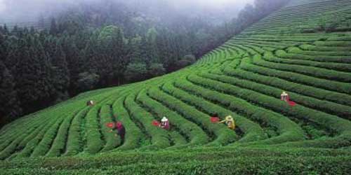
  • The ideal crop for areas with rainfall above 200 cm and sloping hills – Tea
  • The crop which requires a large amount of rainfall and no standing water – Tea

Also Read: Minerals: India’s Mineral Resources

 Crops : Largest Producers

  •  The largest producer of paddy in India-West Bengal
  • The largest producer of wheat in India-Uttar Pradesh
  • The largest producer of sugarcane in India – Uttar Pradesh
  • The largest producer of groundnut in India – Gujarat
  • The largest producer of tea in India -Assam
  • The largest producer of coffee in India – Karnataka
  • The largest producer of jute in India- West Bengal
  • The largest producer of tobacco in India – Andhra Pradesh
  • The largest producer of bananas in India – Tamilnadu
  • The largest producer of saffron in India – Jammu & Kashmir
  • The largest producer of onion in India- Maharashtra
  • The largest producer of black pepper in India – Kerala
  • The largest producer of cotton in India – Gujarat
  • The largest producer of bamboos in India – Assam
  • The largest producer of litchis in India – Bihar

Read Also: Crops of the world

 Crops in India

  • The crop which is sown in largest area in India – Rice
  • The crop whose production is the largest in India – Sugarcane
  • The cereal crop whose production is the largest in India – Rice
  • The agricultural produce which has the highest percentage share of imports – Edible Oil
  • The agricultural produce which has the highest percentage share of exports – Rice

 Facts about Soils

  •  The soil most common in Indogangetic plains – Alluvial
  • The soil which swells when wet and develops cracks when dry – Black
  • The soil which owes its color to oxides of iron – Laterite
  • The soil which requires the least use of fertilizers – Alluvial
  • The soil which requires the least tiling – Black
  • The kind of soil which is treated with gypsum to make it suitable for cropping – Alkaline soil
  • The soil which is poor insoluble salts – Laterite
  • The soil which is rich in surface accumulation of organic matter – Peaty soil
  • The soil which is most suitable for cultivation of cotton – Black

Must Read:

Monsoon, Floods, and Droughts

Types of Indian soils and their distribution

Soils in India

Rivers, Waterfalls, and Glaciers

31 Important Mountain Pass in India

17
mountain pass india

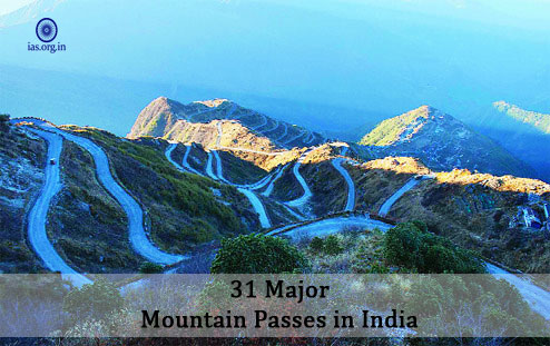
Mountain pass is a connectivity route through the mountain range. It is highly important transport gateway to connect different parts of country, and also with neighboring countries.

Following is the list and information about 31 important mountain pass in India.

Mana Pass

This mountain pass, connecting Uttarakhand with Tibet, is situated at an elevation of 5545 m above sea level in Greater Himalayas at some places it reaches  5611 m. During the winter season it remains snow-covered for about six months.

Thang La

This mountain pass, the second highest motarable montain pass in India after Khardung La, is situated at an elevation of 5359 m above sea level. This mountain pass is in Ladakh (Jammu and Kashmir).

Chang-La (Ladakh with Tibet)

This is a high mountain pass. It is situated at an elevation of over 5360 m above sea level. This pass has been named after Chang La Baba and has a temple dedicated to him. The road, leading to the small town of Tangtse, after Chang La is extremely steep. It remains closed, because of being snow-covered, during the winter season.

Must Read: World’s 10 Greatest – Ocean or Seas, Deserts, and Mountains

Debsa Pass

This high mountain pass, between the Kullu and Spiti districts of Himachal Pradesh in Greater Himalayas, is located at an elevation of 5360 m above sea level. This pass is popularly known for providing an easier and shorter alternative to the traditional Pin-Parbati Pass route between Kullu and Spiti.

Khardung La

This mountain pass, connecting Leh with Siachin glacier, is the highest motarable pass in the country. It is situated at an elevation of more than 5359 m above sea level. During the winter season the road, however, remains closed.

Qara Tagh Pass

This mountain pass, an offshoot of the Great Silk Road, is situated at an elevation of more than 6000 m above the sea level in the Karakoram Mountains. During the winter season it remains covered with snow.

Aghil Pass (Karakoram-Lodak)

This mountain pass, connecting Ladakh with Xinjiang (Sinkiang) province of China, is located to the north of K2 in the Karakoram at an elevation of about 4805 m above the sea level. During the winter season it remains closed from November to the first week of May.

Lanak La:

Connecting Ladakh with Lhasa this mountain pass is located at an elevation of 5466 metres in Aksai-China (Ladakh). The Chinese have constructed a road to have connectivity between Xinjiawg (Sinkian) Province of China and Tibet.

Pangsang Pass (Arunachal Pradesh):

Connecting Arunachal Pradesh with Mandalaya (Myanmar), this mountain pass is located at an altitude of more than four than metres above Sea level.

Mangsha Dhura Pass:

Connecting Uttrakhand with Tibet, this mountain pass is located at an altitude of 5490 metres in the district of Pithoragarh. Landslides create great problems for pilgrims and tourists who cross this pass to reach Mansarovar.

Also Read: The Ocean and The Sea: Forms and Benefits

Traill’s Pass

Located at the end of Pindari Glacier, linking Pindari Valley to Milam Valley in the Pithorgarh and Bageshwar districts of Uttrakhand, this mountainpass is situated at an elevation of 5212 m above sea level. This pass is very difficult to cross because of its steepness and ruggedness

Shipki La

Connecting Himachal Pradesh with Tibet, this mountain pass, through which river Satluj enters India from Tibet, is situated at an altitude of more than 5669 M above Sea level through the Satluj George. The pass, representing Indian National Highway, is India’s third border post for trade with China next to Nathula in Sikkim and Lipulekh in Uttrakhand. During the winter season it remains covered with snow.

Zoji-La

Connecting Srinagar with Kargil and Leh, this mountain pass is situated at an altitude of 3528m above the sea level. From December to mid-May it remains closed because of heavy snowfall. Beacon Force of Border Road Organisation (BRO) that is responsible for cleaning and maintenance of the road during the winter season; try to keep the road open for most part of the year. In 2013, the centre had declared the Srinagar-Zoli-La Road a National Highway (NH-ID).

Rohtang Pass

Connecting the Kullu, the Lahul and Spiti Valleys of Himachal Pradesh, this mountain pass is situated at an altitude of 3979m above sea level. Here Border Road Organisation has constructed excellent accessable road. Heavy movement of military vehicles, buses, taxis; trucks and goods trains cause traffic jams that are common occurrences.

Pensi La

Connecting the Valley of Kashmir with Kargil (Ladakh) this mountain pass is situated at an elevation of more than 4400 m above sea level in the Greater Himalayas. From November to Mid-May it remains covered with snow.

Niti Pass

Connecting Uttrakhand with Tibet this mountain pass is located at an altitude of 5068 m above sea level. During the winter season, between November and mid-May, it remains covered with snow.

Nathu La (Sikkim)

Located on the Indo- China border, this mountain pass, forming part of an offshoot of the ancient Silk Road, is at an altitude of 4310m above sea level. Nathu–La, one of the three trading border posts between India and China, was responded in 2006 after the 1962 war.

Also Read: Types of Indian soils and their distribution

Likhapani (Arunachal Pradesh)

Connecting Arunachal Pradesh with Myanmar this mountain pass is located at an altitude of more than four thousand metres above sea level. It remains open throughout the year trade and transport.

Mulinga La (Uttrakhand)

Connecting Uttrakhand with Tibet, this seasonal mountain pass is situated north of Gangotri. During the winter season it remains covered with snow.

Shencottah Gap

Connecting Madurai city of Tamil Nadu with Kottayam city of Kerala this mountain pass is situated in Western Ghats. Shencottah is a small town also near this pass in Tamil Nadu.

Lipu Lekh (Uttrakhand)

Connecting Uttrakhand with Tibet this mountain pass, one of India’s important border post for trade with China, is situated in the Pithorgarh district. The pilgrims travel through this pass to reach Mansarovar. However, Landslides in the rainy season and avalanches in winter cause great problems for movements and transportation. Elevation is 5334 m.

Pir-Panjal Pass

Connecting Jammu with Srinagar this traditional pass lies on the Mughal Road. The mountain pass was closed down after partition of the sub-continent. It facilitates the easiest and shortest metalled road access from Jammu to the Valley of Kashmir.

Imis La

The pass, providing an easy access between Lodakh and Tibet (China), is located at an altitude of over 4,500m above sea level. It remains closed during the winter season and has a difficult terrain and steep slopes.

Burzail Pass (Srinagar with Kishan-Ganga Valley)

Connecting Kashmir Valley with Deosai Plains of Ladakh this mountain pass is located at an altitude of 4100 m above sea level. During winter season it remains closed for trade and transport because of being covered with snow.

You May Also Read: The Himalayas: An insight into their evolution and importance

Dihang Pass

Connecting Arunachal Pradesh with Mandalay this mountain pass is situated at an altitude of about 4000m in the state of Arunachal Pradesh.

Bomdila Pass (Arunachal Pradesh)

Connecting Arunachal Pradesh with Lhasa (the capital of Tibet), this mountain pass is situated to the east of Bhutan in the Greater Himalayas in Arunachal Pradesh at an elevation of about 2217 m above sea level. Owing to the snowfall and adverse weather in the winter season it remains closed.

Diphu Pass

This traditional mountain pass between India and Myanmar, situated in the eastern part of Arunachal Pradesh, provides an easy and shortest access to Mandalaya (Myanmar). It remains open throughout the year for transportation and trade. Elevation of this pass is at 4587 m.

Banihal Pass (Jawahar Tunnel)

Connecting Jammu with Srinagar this mountain pass is situated at an altitude of 2832 m above sea level in the Pir-Panjal. Named after Pandit Jawaharlal Nehru, the Jawahar Tunnel, constructed for round-the-year surface transport, was inaugurated in December 1956 because the pass remains closed during the winter season because of the snow-cover.

Kunjerab Pass (Karakoram)

Connecting Ladakh and the Xinjiang Province of China, this traditional mountain pass is situated at an altitude of 4693 m above sea level in the Karakoram Mountains. During the winter season from November to mid-May it remains covered with snow.

Bara Lacha

Situated on the National Highway and connecting Manali and Leh, this mountain pass is located at an altitude of a 4890 m above sea level in the state of Jammu and Kashmir. Because it is a high Mountain pass, it remains covered with snow from November to mid-May.

Jelep La

Connecting Sikkim with Lhasa this mountain pass that passes through the Chumbi Valley, is located at an altitude of 4270 m above sea level.

You May Also Read: Climate Change, Technology and Energy Sustainability

Mineral – Characteristics, Properties and Types

0

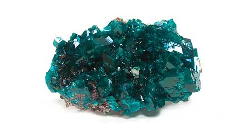
Minerals are solid substances that occur naturally. They can be made from a single element (like gold or copper) or from a combination of elements. The Earth is made up of thousands of different minerals. Minerals have a specific chemical structure which is the same throughout the entire mineral. Rocks, on the other hand, are composed of a variety of different minerals and are not consistent throughout their structure.

Must Read: Rock – Bunch of Different Minerals

Characteristics of Minerals

Some common characteristics of minerals include:

  • Solid – All minerals will be solids at normal temperatures on Earth.
  • Naturally occurring – Minerals occur in nature. Solids that are made in a chemistry lab don’t count as minerals.
  • Inorganic – Minerals don’t come from plants, animals, or other living organisms.
  • Fixed chemical structure – Specific minerals will always have the same chemical formula. They will have the same combination of elements. Minerals also generally are formed with a crystal structure.

Also Read: Minerals: India’s Resources

Properties of Minerals

Different minerals are often defined by the set of properties described below:

  • Luster – Luster describes how well a mineral reflects light. Examples of luster include glassy, metallic, brilliant, and dull.
  • Hardness – The hardness describes how easy it is to scratch the surface of a mineral. Scientists often use the Moh’s scale to describe hardness. Using the Moh’s scale, a “1” is the softest mineral and a “10” is the hardest. One example of hardness is the diamond. Diamond has a hardness of 10 because it is the hardest of all the minerals.
  • Streak – Streak is the color of the mineral in powdered form. One way to determine the streak is to rub the mineral across a rough hard surface like a tile.
  • Cleavage – Cleavage describes how a mineral breaks up into pieces. Some minerals break up into small cubes while others may break up into thin sheets.
  • Specific Gravity (SG) – The specific gravity measures the density of the mineral. It is measured in comparison to water where water has a specific gravity of 1. For example, pyrite has a specific gravity of 5 and quartz has a specific gravity of 2.7.
  • Color – Although the color is often used to describe a mineral, it sometimes isn’t the best way to tell one mineral from another as one type of mineral can come in several different colors.

Have a Look at: Types of Indian soils and their distribution

Types of Minerals

There are many different types of minerals, but they are often divided into two groups: silicates and non-silicates. Silicates are minerals that contain silicon and oxygen. Over 90% of the Earth’s crust is made up of silicates. The rest of the minerals are lumped into a group called non-silicates.

Some important non-silicate minerals include:

  • Carbonates – Carbonates contain carbonate (CO3) combined with some other element. Calcite is a mineral made from carbonate and calcium.
  • Halides – Halides contain a halogen element as the main element. Table salt (NaCl) is a halide mineral made from the halogen chlorine (Cl) and sodium (Na).
  • Oxides – Oxides are minerals where the main element is oxygen. Chromite is an oxide mineral made from iron, chromium, and oxygen.
  • Sulfides – Sulfides contain sulfur and one or more metals or semimetals. Pyrite is a sulfide made from iron and sulfur.

Native elements such as copper, gold, diamond, graphite, and sulfur can be thought of as a third group of minerals.

You May Also Read: The Ocean and The Sea: Forms and Benefits

Facts about Mineral

  • Scientists who study minerals are called mineralogists.
  • Around 99% of the minerals in the Earth’s crust are made up of eight elements including oxygen, silicon, aluminum, iron, calcium, sodium, potassium, and magnesium.
  • Common minerals include quartz, feldspar, bauxite, cobalt, talc, and pyrite.
  • Some minerals have a different colored streak than the color of their body.
  • A gem is a piece of rare minerals such as diamond, emerald, or sapphire that is cut and polished to shine.
  • Certain minerals are needed by our bodies so we can grow healthy and strong.

Don’t Miss:

Water Resources of India

Fossils

Erosion

Crops of the world

5
crops of the world

Groundnuts are grown in many parts of the world, in some countries they are eaten after being roasted and salted. Oil is also extracted from these nuts and is used as the cooking medium in many countries. Besides this, crops of the world are also used as animal feed.

Soya Beans are beans which rich in proteins and as such provide nourishment to both animals and humans. Edible oil is also extracted from these beans. The maturity  period of soybean crop ranges from 50 to 145 days. It is a Kharif crop.

Sunflowers are grown in many parts of the world for their seeds which provide an edible oil. The maturity  period of Sunflower crop ranges from 80-115 day. It is grown in both Kharif and rabi seasons.

Read Also: Types of Indian soils and their distribution

Tea and Cocoa are both cash crops of the world. Tea is grown on hill slopes in areas which have plenty of rains on the other hand cocoa plant require a moist and heavy soil. Tea is popular as beverage while cocoa is used for many things amongst which the making of chocolates is most important.

Coffee is also a cash crops of the world which requires hot climate and both dry and wet season. Frost or drought can easily damage these crops of the world. Coffee beans are roasted and ground into a fine powder which is used for making a beverage. Most of the worlds’ coffee is grown in Brazil.

Sugar beet grows in a rich and deep soil in a temperate climate and most of it is grown in Europe.

Fruits are produced all over the world earlier the consumption of these was restricted to the areas in which they were grown but with the advent of the faster mode of transportation and canning techniques these have become major cash crops of the world which are exported from the areas in which they are grown.

Wheat is a very important grain crop grown mostly in the temperate regions in some monsoon areas as a winter crops of the world.

Must Read: Major Crops of India

Corn is used mostly as animal feed and its needs warm climate with plenty of the sunshine and irrigation or summer rain. It is consumed by humans as food in India, Africa, Latin America, etc.

Oats are mostly grown in temperate regions as cattle feed but is also used as a breakfast food in the form of oatmeal or porridge.

Rye is an important food stuff in north Asia and eastern Europe and is the hardest of all cereals. Poland is the largest producer.

Barley is largely used as an animal feed or by the braveries and malt industries. It can be harvested within eight weeks of seeding.

Potatoes grow all over the world but largely in the temperate climate with lots of rain. It is an important food crops of the world though it has less nutritious value compared to grain crops.

Millets is a common name of the variety of plants in the grass family,  of the sorghum is the most important, India is the largest producer of these.

Sugarcane requires solid conditions which are similar to sugar beet but requires a tropical climate. Sugarcane plants grow up to fifteen feet in height. When ready for harvesting the stout shafts of cane are cut close to the ground and the leaves are removed. The juice extracted from this cane is used for making sugar.

Don’t Miss: Monsoon, Floods, and Droughts